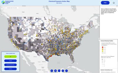
(Washington, DC) Today, Environmental Defense Fund (EDF) launched its Chemical Exposure Action Map, a tool designed to help visualize health harms from multiple chemical exposures and encourage the U.S. Environmental Protection Agency (EPA) to consider the fuller picture of those harms when assessing risks.
When conducting Toxic Substances Control Act (TSCA) risk-assessments, EPA typically considers the risks from one chemical and one facility at a time—but communities are exposed to multiple chemicals simultaneously that can cause the same health impacts, such as cancer, developmental harms and asthma. Many–including scientists, communities, some regulators, and advocacy groups–have long called for EPA to take a cumulative approach to assessing the risks from these chemicals.
The Chemical Exposure Action Map employs user-friendly, interactive graphics and action alerts to offer a more realistic approach that recognizes exposure to multiple toxic chemicals that cause the same harms and their associated cumulative health risks.
The map includes data on facilities releasing chemicals that EPA has designated “high priority” for assessment and regulation under TSCA. The facilities release these chemicals into the air, soil and water.
“We hope this map will help users encourage EPA to take a more holistic look at the risks communities face from the many chemicals that cause similar harms,” said Maria Doa, Senior Director, Chemicals Policy.
Map users will be able to search for chemical releases in their community, state or congressional district and to view:
- Chemical exposures by the health impacts they cause, such as cancer, asthma and harm to pregnant women and infants.
- Information on the size of these chemical releases.
- Weighted relative risk levels for the facilities in their community that consider the total amount of chemicals released and their relative toxicity.
- Community demographics and baseline vulnerability indicators, as defined by the Climate Vulnerability Index.
The map also gives users the ability to send a letter directly to EPA, urging the agency to consider the risks from toxic chemicals that cause the same harms together to better protect community health. The letter to EPA will bring in localized chemical release information based on facilities in the near vicinity – showing EPA the need to assess the real-world chemical risks communities face.
The map also includes the congressional district information for each facility–giving users information they can use to advance advocacy efforts for improving risk assessments and regulations that match the real-world, cumulative risks communities face.
Environmental Defense Fund
www.edf.org


